 Glacier Park Chat
1 Week, 3 Big Hikes
Re: 1 Week, 3 Big Hikes
Several years ago I was very interested in visiting Sue Lake, the overlook to Margaret Lake, and Chaney Glacier. In particular, I wanted to photograph Sue Lake. I seriously considered the route you described. The topo maps make it looks doable. But, I did read about someone who tried it, and remarked that it was a lot steeper then the map had showed. If I recall correctly, they made a descent commitment that couldn't be reversed. Then the descent got scary. They commented that it is a bad route. But, I guess that it also depends upon your skill level. I decided thereafter to abandon access on that route. But yes, it would shorten the route considerably. Going the opposite way, would be much safer because you could abandon the route without the commitment. If you decide to do this route, make sure you do a lot of research so that you are not surprised. Maybe someone else here has done the route.
-
derek.larson
- Posts: 47
- Joined: Sat Jun 08, 2013 3:32 pm
- Gender?: Male
- Please add the numbers(11): 11
- Location: Columbus, GA
Re: 1 Week, 3 Big Hikes
If I have my forum nicknames and real names associated with their identities, I believe Ear Mountain must have done this route before. I think he's mentioned in J.G. Edwards' book about a 1987 hike on this particular route (please correct me if I'm wrong)....something about massive crevases in the glacier, etc.
I'm dead-set on 2 of the 3 Big Hikes in my proposed itinerary, those 2 being Daw-Pit and the Skyline Experience. Big Hike #3 is still being evaluated. Possible #3 options:
-Many Glacier to Goat Haunt (via Ptarmigan Tunnel & Belly River)
-Many Glacier to Goat Haunt (via Iceberg Notch & northern Highline)
-NEW!: North Circle shortcut route (Many Glacier>Iceberg Notch to northern Highline>Chaney Glacier shortcut>Belly River>Ptarmigan Tunnel>Many Glacier...40 miles?)
-Option 4: haven't thought of one yet
Thanks for the input.
Derek
Re: 1 Week, 3 Big Hikes
You can read his brief description of the route here. It really depends upon your skill level. I would describe this route as more mountaineering then hiking. Likely to be more icy later in the season. Probably more snow earlier in the season, but a slide is also more possible. From pictures I looked at, when you get near the top it gets real steep, and you climb up a shoot with cramp-ons and an ice axe. I am guessing, but probably 40-45 degree climb up an icy shoot. Personally I would do it as a team and probably use ice screws and a rope. But, I haven't done it. Ear Mtn has, and he can describe the route better then me.I believe Ear Mountain must have done this route before.
And, even if you got down from the steep section, you will have to get across the glacier. Probably take up a lot of time to do it safely.
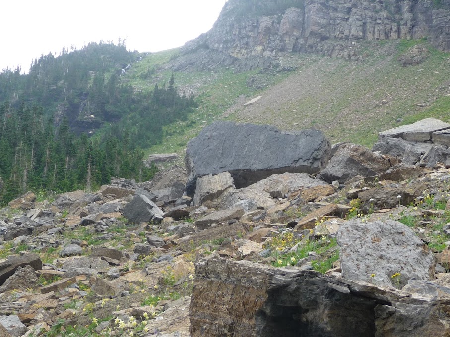
You can see a picture of Chaney Glacier from the Sue Lake Bench here
-
derek.larson
- Posts: 47
- Joined: Sat Jun 08, 2013 3:32 pm
- Gender?: Male
- Please add the numbers(11): 11
- Location: Columbus, GA
Re: 1 Week, 3 Big Hikes
Mike,
That was very helpful. I especially liked the photo of Chaney Glacier. I do realized it's significantly more challenging than just another patch of snow, which it appears in the image. The notch is pretty obvious, something I was wondering about. Thanks.
Derek
That was very helpful. I especially liked the photo of Chaney Glacier. I do realized it's significantly more challenging than just another patch of snow, which it appears in the image. The notch is pretty obvious, something I was wondering about. Thanks.
Derek
-
Heff936

- Donator

- Posts: 1146
- Joined: Tue Apr 25, 2006 1:51 pm
- Please add the numbers(11): 0
- Location: Indianapolis, Indiana
- Been thanked: 1 time
Re: 1 Week, 3 Big Hikes
I've hiked up to the Sue Lake plateau from about 2/3rds of the way up Stoney Indian Pass and visually checked out the glacier crossing from there. The crossing looked doable but I didn't really get close enough to see how many crevasses were visible. I certainly wouldn't do it without being roped to companions since I'd expect there to be several crevasses to deal with and some may not be evident. There is a steep ramp angling back toward Raven Quiver Falls that can take you down to the Stoney Indian Pass trail. I'm pretty sure Edwards discusses a route to the actual pass.
I'm looking forward to your trip report.
Heff
I'm looking forward to your trip report.
Heff
-
Ear Mountain

- Moderator & 2.1 Donator

- Posts: 4982
- Joined: Fri Jun 22, 2007 9:53 pm
- Gender?: Male
- Please add the numbers(11): 11
- Location: Choteau, Montana
- Has thanked: 38 times
- Been thanked: 42 times
- Contact:
Re: 1 Week, 3 Big Hikes
It is a personal choice of mine to not discuss off trail or mountaineering routes in these forums visited primarily by hikers.
Text and photos Copyright 2007-2023.
Re: 1 Week, 3 Big Hikes
Personally, I think that the Sue Lake Plateau is worth spending a day exploring. The ramp up on the east side of Raven Quiver Falls (560') is fairly easy without a full pack.
Then spend another day hiking up the Mokowanis lake, Margaret Lake, Ipasha Lake. But, most people do not allot two extra days for this exceptional region when doing the Northern Loop. Here is a Summit Post review of the Mokowanis Valley . At the beginning of the review, it appears there are two pictures looking down from the Sue lake Bench.
Then there are the summits which provide exceptional views.
As for the Edward's "short-cut", I don't think it is worth dragging 10 pounds of gear to descend and hike across the Chaney glacier. Crevasses are surely there. Too steep to not have them. Maybe when the glacier melts more in the coming years there might be a way to descend and skirt around the glacier. Then it might be a real nice route. In my eyes, the Sue Lake Plateau is exceptional and worth exploring.
-
Heff936
- Donator
- Posts: 1146
- Joined: Tue Apr 25, 2006 1:51 pm
- Please add the numbers(11): 0
- Location: Indianapolis, Indiana
- Been thanked: 1 time
Re: 1 Week, 3 Big Hikes
Mikie:mikie wrote:Personally, I think that the Sue Lake Plateau is worth spending a day exploring. The ramp up on the east side of Raven Quiver Falls (560') is fairly easy without a full pack.
Then spend another day hiking up the Mokowanis lake, Margaret Lake, Ipasha Lake. But, most people do not allot two extra days for this exceptional region when doing the Northern Loop. Here is a Summit Post review of the Mokowanis Valley . At the beginning of the review, it appears there are two pictures looking down from the Sue lake Bench.
Then there are the summits which provide exceptional views.
As for the Edward's "short-cut", I don't think it is worth dragging 10 pounds of gear to descend and hike across the Chaney glacier. Crevasses are surely there. Too steep to not have them. Maybe when the glacier melts more in the coming years there might be a way to descend and skirt around the glacier. Then it might be a real nice route. In my eyes, the Sue Lake Plateau is exceptional and worth exploring.
I agree. I love that area. I have only been on the Sue Lake Plateau once on a very hot sunny day but thoroughly enjoyed it. I consider Margaret the most beautiful lake in the park and tried to get up to Ipasha once but obviously took the wrong route since we were trapped by thick willows. I guess wading the lake might be the best way, but if you have another suggestion I'd welcome it.
Heff
-
paul

- Donator
- Posts: 1705
- Joined: Tue Oct 10, 2006 7:42 pm
- Gender?: Male
- Please add the numbers(11): 11
- Location: MA
- Has thanked: 66 times
- Been thanked: 46 times
Re: 1 Week, 3 Big Hikes
In case anyone is interested here's a photo of the ramp up to the Sue Bench from Stoney Indian Pass trail
We are in the mountains and the mountains are in us. - John Muir
Re: 1 Week, 3 Big Hikes
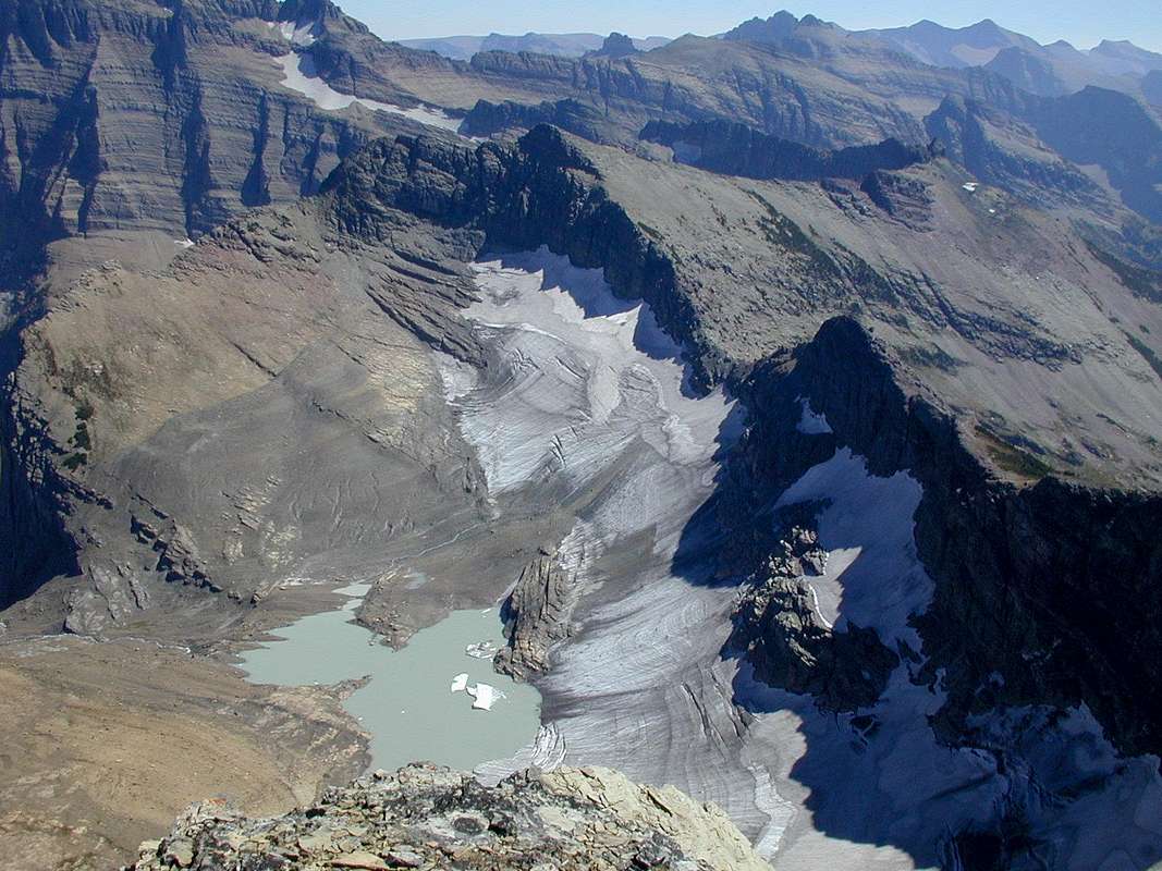
I did a little checking on Chaney Glaicer last night.
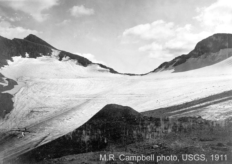
This image from the USGS shows the Chaney Glacier in 1911. You could just hike up from 50-Mtn CG and walk right onto the glacier. I suspect that the access to the top of Chaney Glaicer was similar when Edwards described the route.
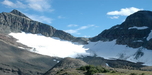
This is the latest image from the USGS showing much of Chaney Glacier melted away. The rim of the cirque is also showing. The primary concern is access from the notch over the rim and onto Chaney Glacier. You could also hike up the ridge (left side of the image), and then come down and avoid the entire glacier.
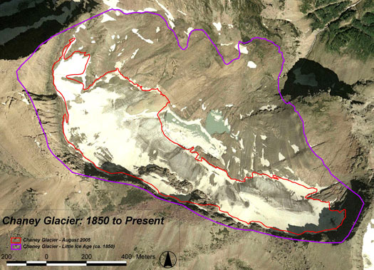
This USGS image shows the image dimensions from the past to the present.
So, the real concern is the access over the rim onto the glacier. I contacted someone who went this route a couple years ago. He said the hardest part was the climb up from 50-Mtn CG to the notch. He didn't specify his route up to the notch. Didn't have a problem getting onto the glacier. But, you have to remember that this was a couple of years ago, so the access over the rim could have gotten more difficult over time.
I also checked around for a more current image of Chaney Glacier. Here is a Hi-res image on summitpost of Chaney Glacier from Kipp. You can clearly see the rim poking up.
If you are really interested, you can always get up early, while camping at 50-Mtn CG, and hike up to the notch and determine the feasibility of the descent onto the Glacier. That would remove any unexpected issues with the route. At an absolute minimum, I would wear crampons. I wouldn't substitute with micropikes. An ice axe or something to self-arrest would be recommended. I would also do the route with at least another experienced hiker. I wouldn't bring someone inexperienced. I would then hike straight down, and turn north towards Sue Lake at the base of the tarn. You would have to also cross the run off from the tarn. At least, this would be my plan. You might come up with a different plan. I didn't look at the glacier with Google Earth, but I would recommend it.
This image from the USGS shows the Chaney Glacier in 1911. You could just hike up from 50-Mtn CG and walk right onto the glacier. I suspect that the access to the top of Chaney Glaicer was similar when Edwards described the route.
This is the latest image from the USGS showing much of Chaney Glacier melted away. The rim of the cirque is also showing. The primary concern is access from the notch over the rim and onto Chaney Glacier. You could also hike up the ridge (left side of the image), and then come down and avoid the entire glacier.
This USGS image shows the image dimensions from the past to the present.
So, the real concern is the access over the rim onto the glacier. I contacted someone who went this route a couple years ago. He said the hardest part was the climb up from 50-Mtn CG to the notch. He didn't specify his route up to the notch. Didn't have a problem getting onto the glacier. But, you have to remember that this was a couple of years ago, so the access over the rim could have gotten more difficult over time.
I also checked around for a more current image of Chaney Glacier. Here is a Hi-res image on summitpost of Chaney Glacier from Kipp. You can clearly see the rim poking up.
If you are really interested, you can always get up early, while camping at 50-Mtn CG, and hike up to the notch and determine the feasibility of the descent onto the Glacier. That would remove any unexpected issues with the route. At an absolute minimum, I would wear crampons. I wouldn't substitute with micropikes. An ice axe or something to self-arrest would be recommended. I would also do the route with at least another experienced hiker. I wouldn't bring someone inexperienced. I would then hike straight down, and turn north towards Sue Lake at the base of the tarn. You would have to also cross the run off from the tarn. At least, this would be my plan. You might come up with a different plan. I didn't look at the glacier with Google Earth, but I would recommend it.
Re: 1 Week, 3 Big Hikes
The problem with herd trails is that they fractionalize. Ending up on an undesirable herd trail is inevitable. It happens to all of us. I find it is best to backtrack as soon as I discover my mistake. Pressing on always seems like a mistake. And, the worst problem is that once you have made the mistake, you will make the same mistake in the future. Your brain is wired to follow trails that look familiar. The best routes seem to be hiking up higher on the side walls to miss the wherever water might sit, which allows the willows to grow. You might check around to see if someone has some GPS tracks of a good route that avoids the difficult spots.I consider Margaret the most beautiful lake in the park and tried to get up to Ipasha once but obviously took the wrong route since we were trapped by thick willows.
-
derek.larson
- Posts: 47
- Joined: Sat Jun 08, 2013 3:32 pm
- Gender?: Male
- Please add the numbers(11): 11
- Location: Columbus, GA
Re: 1 Week, 3 Big Hikes
Mikie,
Wow, that's great info. The semi-proposed "bypass the glacier to the left side of the photo" idea would be tough based on what the ridge looks like in the hi-res photo link.
Thanks.
Derek
Wow, that's great info. The semi-proposed "bypass the glacier to the left side of the photo" idea would be tough based on what the ridge looks like in the hi-res photo link.
Thanks.
Derek
-
derek.larson
- Posts: 47
- Joined: Sat Jun 08, 2013 3:32 pm
- Gender?: Male
- Please add the numbers(11): 11
- Location: Columbus, GA
Re: 1 Week, 3 Big Hikes
An August 2009 trip report of the route over the Chaney Notch: http://www.nwhikers.net/forums/viewtopic.php?t=7977838.
-
McNeill78

- Posts: 43
- Joined: Fri May 10, 2013 2:53 pm
- Gender?: Male
- Please add the numbers(11): 11
- Location: Mooresville, North Carolina
Re: 1 Week, 3 Big Hikes
I think you should take a look at the pass to the northwest of Cathedral as a short cut from Fifty to Stoney. I believe this is the shortcut Edward described in his book to avoid the descent to the river and the climb out. I considered this last year but got caught in a 40 hour rain (Aug 2/3?) as we left from Cosley to Stoney and thought better to take the trail.
I believe if you are coming from Fifty the crux will be the ascend to that pass. We believed the northernmost chute (shows as a shadow on Goggle Earth) would provide the best spot.
From the pass you can still bail if necessary. There was very little snow on the east side of the pass as we observed it going up to Stoney and no snow on the western exposure.
The Sue Bench is a very desirable area from all reports and pictures I have seen. However it appears this is not a shortcut to Stoney but an alternative to Stoney for a North Loop route.
-
derek.larson
- Posts: 47
- Joined: Sat Jun 08, 2013 3:32 pm
- Gender?: Male
- Please add the numbers(11): 11
- Location: Columbus, GA
Re: 1 Week, 3 Big Hikes
Yes, that is the other of the two shortcuts Edwards mentions, and the one not affected by the glacial melt. It's probably the wiser of the two options.